


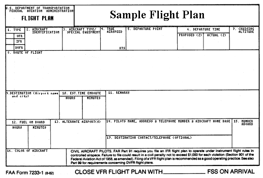
 After you have completed gathering preflight information, you should file a Flight Plan for all but the most routine flights. You can do this either by talking directly to a Flight Specialist (often after completing a weather briefing), or by using the Fast File system at the McMinville AFSS (call 1-800-WX-BRIEF and press 3). Provide the flight specialist or the Fast File recording system the following information in a slow, clearly spoken manner:
- Type of flight (VFR / IFR / DVFR)
- Aircraft identification
- Special equipment code
- True airspeed (kts)
- Departure point
- Departure time (proposed)
- Cruising altitude
- Route of flight
- Destination (airport name and city)
- Estimated time en route (hours) (minutes)
- Remarks
- Fuel on board (hours) (minutes)
- Alternate airport(s)
- Pilot's name, address, telephone number, aircraft home base
- Number aboard
- Color of Aircraft
- Destination contact/telephone
(Willamette pilots should list Willamette Aviation, 503-678-2252)
 Also mention that you will close your flight plan with McMinnville Flight Service upon arrival, or another AFSS if your destination is an airport outside of Oregon.
To see a full-sized FAA flight plan form, click here.
X - No transponder
T - Transponder with no altitude encoding capability
U - Transponder with altitude encoding capability
D - DME, no transponder
B - DME, transponder with no altitude encoding capability
A - DME, transponder with altitude encoding capability
M - TACAN-only, no transponder
N - TACAN-only, transponder with no altitude encoding capability
P - TACAN-only, transponder with altitude encoding capability
C - RNAV, transponder with no altitude encoding capability
R - Required Navigational Performance. (Denotes capability to operate in RNP designated airspace and routes.)
I - LORAN, VOR/DME, or INS, Transponder with Mode C
W - Reduced Vertical Separation Minima (RVSM)
G - GPS/GNSS equipped aircraft with en route, terminal, and GPS approach capable
Y - LORAN, VOR/DME, or INS with No Transponder